“The [Green] Line is long gone”: Gilo to be expanded, creating annexable bloc that includes Cremisan Valley and extends to Har Gilo
Published:
5 Jan 2016
On Wednesday 16 December 2015, Jerusalem’s Local Planning Committee gave the final go-ahead for a plan to construct 891 residential units on the slopes south of the neighborhood of Gilo. Gilo is located on West Bank land that Israel annexed unilaterally to Jerusalem and still constitutes occupied territory. Therefore, under international law, Gilo’s status is no different than those of any other Israeli settlement in the West Bank. The broader urban building plan was approved by the Jerusalem Regional Planning Committee in December 2012. However, as the land slated for construction is split among multiple owners – including the Israel Land Authority, the Jewish National Fund, and the private “Gilu Beilo” company, to name a few - the Local Planning Committee had to give its seal of approval for unifying and re-parceling the various plots to enable construction.
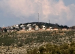
 Construction work for expansion of Gilo in 2011. Photo by Baz Ratner, Reuthers, 16 Jan. 2011
The committee was scheduled to review the reorganization plan in November 2015, but discussion was postponed at the last minute to avoid a diplomatic incident during PM Benjamin Netanyahu’s visit to Washington. In December the committee approved the plan for deposit for public review, thereby greenlighting the construction plan.
The plan is one of three the District Committee approved for Gilo in 2012. A second plan, similar in scope, is set to expand the settlement west towards the Palestinian village of al-Walajah, whose development has been entirely blocked by the Separation Barrier. Israel has already expropriated half of the village’s land, confiscating some for the original construction of Gilo and seizing other parts by military order to establish the settlement of Har Gilo. The third plan will enable construction of about hundred residential units close to the Palestinian neighborhood of Beit Safafa. Unlike the first plan, the other two plans apply to territory that Israel has declared “state land” – a procedure based on a skewed legal interpretation aimed at transferring Palestinian-owned land to settlements. State land status obviates the need for approval to unify and re-divide the land before the plans can be deposited for review. With regard to the plan that will expand Gilo toward al-Walajah, tenders have already been issued for building the residential units and contractors are expected to receive orders approving construction in the coming weeks.
According to Jerusalem Municipality figures, 32,000 people lived in Gilo in about 9,000 residential units. The three plans detailed above would increase the number of approved residential units in Gilo by 23.5 percent.
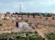
 Segment of south Jerusalem map, courtesy of human rights NGO Ir Amim
Ofer Ayoubi, the head of Gilo’s Community Center, welcomed the plan: “If you think Gilo is in the Occupied Territories, I suggest you visit us and see the contiguity between Gilo and [the neighborhoods of] Katamon, Talpiot, Har Homa, and Malha. The [Green] Line is long gone here.” Indeed, the fact that the Jerusalem Local Planning Committee approved these plans is yet another example of the Israeli government’s policy to expand and entrench the existence of settlements and blur the distinction between Israel proper and the West Bank.
The plan to expand Gilo to the south was approved shortly after construction work on the section of the Separation Barrier on the other side of the Cremisan Valley was renewed. The route of the barrier was designed to cut off the Palestinian residents of nearby Beit Jala from their privately-owned farmland in the valley and achieve de-facto annexation of the land and of Har Gilo to Israel. The southward expansion of Gilo will facilitate the creation of territorial contiguity between Gilo, which lies within Jerusalem’s municipal jurisdiction, and Har Gilo, which is part of the Gush Etzion Regional Council. The Cremisan Valley - a vital source of income to the residents of Beit Jala that also provides them opportunities for recreation - will apparently be turned into a free public space for the residents of Gilo and Har Gilo. This belies the security justifications for the route of the barrier accepted by the High Court of Justice, according to which an empty buffer zone is needed in order to protect Israeli citizens. In fact, these measures taken together are yet another indication of Israel’s policy to annex Palestinian land.
Tags:


هیچ نظری موجود نیست:
ارسال یک نظر