


On 9 July 2004, the International Court of Justice, in The Hague, gave its advisory opinion on the question of the legality of the separation barrier being built by Israel. The opinion was given pursuant to the request of the UN General Assembly of 3 December 2004.
Israel refused to cooperate in the proceeding, contending that the court did not have jurisdiction to hear the matter. In a document that it submitted to the court, Israel argued that the question involved was political and not legal, and should be dealt with bilaterally, between it and the Palestinians. In a majority decision, the court denied Israel's argument. In a minority opinion, one of the judges held that the court did not have sufficient information to render an opinion on the question, and thus lacked the authority to hear it. Before dealing with the substantive matters, the court explained that its opinion related only to those sections of the separation barrier that were built, or will be built outside the Green Line [in the Occupied Territories].
The first main issue discussed in the opinion relates to the effects of the barrier on the right of the Palestinian people to self-determination. The court "recorded" the promise made by Israel that the barrier was intended only as a temporary security measure. However, the court pointed out that there is a grave fear that the barrier's route would create "facts on the ground" that lead to the de facto annexation of the territory and determination of the future borders between Israel and a Palestinian state. The court believed that de facto annexation of parts of the West Bank by Israel would violate the right to Palestinian self-determination.
The second major issue involved the legality of the barrier in light of international humanitarian law. The court rejected Israel's argument that the Fourth Geneva Convention does not apply in the Occupied Territories because the West Bank and the Gaza Strip were never part of a sovereign state. On this point, the court held that, insofar as the territories fell into Israel's hands as a result of war with two states that are party to the Convention, the state must exercise control over the said territory in accordance with the provisions of the Convention.
Specifically, the court found that the separation barrier is intended to assist the settlements, the establishment of which violates Article 49 of the Convention. Also, the court pointed out that the restrictions placed on the local population located between the barrier and the Green Line are liable to lead to abandonment of the land, which also constitutes a violation of Article 49. In addition, the opinion stated that taking control of private land to build the barrier injured private property owners, and thus violated Articles 46 and 52 of the Hague Regulations of 1907 and of Article 53 of the Fourth Geneva Convention.
The third major issue that the court dealt with involved the legality of the barrier under international human rights law. In this context, the court stated unequivocally, and contrary to the position held by Israel, that international human rights law applies in its entirety in occupied territory, along with humanitarian law. The court ruled that the separation barrier violates rights set forth in conventions to which Israel is party. The court mentioned the rights to freedom of movement and the right against invasion of privacy of home and family, which are enshrined in Articles 12 and 17 of the International Covenant on Civil and Political Rights, and the right to work, to an adequate standard of living, health, and education, which are enshrined in Articles 6, 11, 12, and 13 of the International covenant on Economic, Social and Cultural rights.
It should be mentioned that the opinion dealt briefly with Israel's argument that violation of these rights is justified under international law because they are intended for legitimate security purposes. The court stated that Israel has the right and duty to protect its citizens against violence, but its defensive actions must comply with international law. The brief discussion on the possible security justifications for the route of the barrier resulted, in part, from Israel's refusal to present its arguments to the court, and from its decision to suffice with a written statement contending the court lacked jurisdiction.
In its conclusion, the court stated that Israel must cease construction of the barrier, dismantle the parts of the barrier that were built inside the West Bank, revoke the orders issued relating to its construction, and compensate the Palestinians who suffered losses as a result of the barrier. The court also called on the international community to refrain from assisting in maintaining the unlawful situation that has arisen following construction of the barrier, and to take legal measures to cease Israel's violations and to ensure enforcement of the Fourth Geneva Convention.
In June 2002, the government of Israel decided to erect a physical barrier to separate Israel and the West Bank in order to prevent the uncontrolled entry of Palestinians into Israel . In most areas, the barrier is comprised of an electronic fence with dirt paths, barbed-wire fences, and trenches on both sides, at an average width of 60 meters. In some areas, a wall six to eight meters high has been erected in place of the barrier system. Since the Cabinet's decision to build the Separation Barrier, Palestinians have filed dozens of petitions against the Barrier's route. In February 2004, the residents of several villages northwest of Jerusalem petitioned the High Court of Justice (the Beit Sourikcase). In its judgment, the High Court ruled that most of the route to which the petition related was illegal, and that the state must propose another route. ( Beit Sourik ) In light of the judgment, Prime Minister Sharon directed the defense establishment to reconsider the route. A new route was proposed, and the Cabinet approved the amended route in February 2005. As with the previous route, most of the newly proposed route runs through the West Bank , and not along the Green Line. In areas where the Barrier has already been built, the extensive violations of human rights of Palestinians living nearby are evident. Further construction inside the West Bank , in accordance with the Cabinet's decision, will bring about additional human rights violations affecting hundreds of thousands of local residents. The construction of the barrier has brought new restrictions on movement for Palestinians living near the Barrier's route, in addition to the widespread restrictions that have been in place since the outbreak of the current intifada. Thousands of Palestinians have difficulty going to their fields and marketing their produce in other areas of the West Bank . Farming is a primary source of income in the Palestinian communities situated along the Barrier's route, an area that constitutes one of the most fertile areas in the West Bank . The harm to the farming sector is liable to have drastic economic effects on the residents - whose economic situation is already very difficult - and drive many families into poverty. In early October 2003, the OC Central Command declared the area between the Separation Barrier in the northern section of the West Bank (Stage 1) and the Green Line a closed military area for an indefinite period of time. New directives stated that every Palestinian over the age of twelve living in the enclaves created in the closed area have to obtain a "permanent resident permit" from the Civil Administration to enable them to continue to live in their homes. Other residents of the West Bank have to obtain special permits to enter the area. Israel has built gates along the completed sections of the Barrier , through which permit holders are allowed to pass. However, requests of many Palestinians for permits to enter their land are rejected, either on grounds of security, or on the contention that the applicant has not provided sufficient proof of ownership of the land or family relation to the landowner. Also, a permit from the Civil Administration does not guarantee that the holder will be allowed to pass through the gate: when the army declares comprehensive closures on the Occupied Territories , the permits do not apply. Furthermore, many residents have to travel long distances, usually along unpaved roads, to get to their gate. The difficulty and expense in gaining access to their land have turned farming into an unfeasible venture, and many residents do not exercise their right to go to their land and work their primary source of livelihood. In setting the Barrier's route, Israeli officials almost totally ignored the severe infringement of Palestinian human rights. The route was based on extraneous considerations completely unrelated to the security of Israeli citizens. A major aim in setting the route was de facto annexation of land: when the Barrier is completed, some nine percent of the West Bank, containing 60 settlements, will be situated on the western – the “Israeli” – side. Another reason for building the Barrier inside the West Bank was to avoid the political price to be paid if the Green Line were set as Israel's border. The overall features of the Separation Barrier and the considerations that led to determination of the route give the impression that Israel is once again relying on security arguments to unilaterally establish facts on the ground that will affect any future agreement between Israel and the Palestinians. In the past, Israel used "imperative military needs" to justify expropriation of land to establish settlements and argued that the action was temporary. The settlements have for some time been facts on the ground. It is reasonable to assume that, as in the case of the settlements, the Separation Barrier will become a permanent fact to support Israel 's future claim to annex additional land Israel has the right and duty to protect its citizens from attacks. However, the building of the Separation Barrier as a means to prevent attacks inside Israel is the most extreme solution that causes the greatest harm to the local population. Israel preferred this solution over alternate options that would cause less harm to the Palestinians. Even if we accept Israel 's claim that the only way to prevent attacks is to erect a barrier, it must be built along the Green Line or on Israeli territory. |
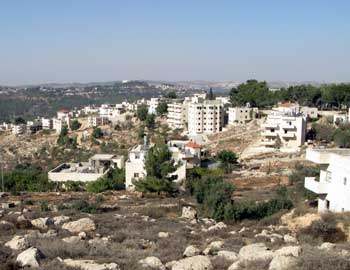
The village of al-Walajah Al-Walajah lies on a ridge south of Refaim Stream. Prior to 1948, the village was located north of the stream, on land later used to establish Moshav Aminadav. In 1948, some residents of the village fled to the village’s farmland that remained on the other side of the Green Line, on which the present village was built. In 1967, Israel’s annexation of East Jerusalem included about one-third of the village’s land. Half of the annexed al-Walajah land was expropriated to build the Gilo neighborhood or requisitioned by military order to build the Har Gilo settlement. The village has 2,000 residents, only a minority of whom hold Jerusalem residency.
Preventing development of the village Over the years, the Jerusalem Municipality has not provided services to the village, and city officials’ visits to the village have primarily been to document illegal building or to demolish structures that were built without a permit. In the late 1990s, the villagers organized and began to prepare an outline plan for the village that arranges the existing building in the village, enables the construction of public buildings and roads, and preserves its unique agricultural terraces. The villagers took their plan to municipal officials and to the Civil Administration’s planning committee, but the planning authorities refrained from dealing with the plan during the second intifada. When the intifada ended, the Jerusalem Municipality refused to discuss the plan on the pretext that the Separation Barrier planned in the area would sever the village from the city. In February 2009, the District Planning and Building Committee issued its final denial of the villagers’ plan, contending that the village lies in a green area, on which building is not allowed. The Separation Barrier in al-Walajah The route of the Separation Barrier in the area, which runs entirely in the West Bank, has been changed a number of times over the years. The original plan placed the village on the western, “Israeli” side of the Barrier, detaching the village from the Bethlehem Governate, to which the villagers belong and from which they receive their services. A winding route was later established to run around the built-up area of the village, separating it from the village’s farmland. This route created a partition between the village and the nearby Har Gilo settlement , and left a single road along which persons could enter or exit the village, in the direction of the adjacent town of Beit Jala. Traffic on this road was to be controlled by a checkpoint at the village gates. Another change in the route, made at the request of the Cremisan Monastery, placed the monastery and its lands on the western side of the Barrier.
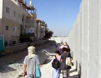
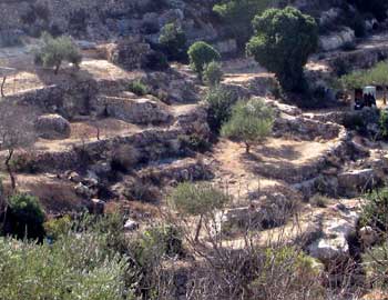
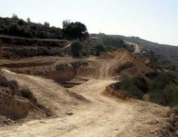
Citing financial constraints, Israel froze construction of the Barrier in the area of al-Walajah until early 2010. When construction recommenced in March 2010, residents of the village petitioned the High Court of Justice, claiming that the construction work was based in part on military requisition orders that were no longer valid, and that some of the work was being carried out on land that had not been seized on the basis of military orders at all. The High Court did not issue a temporary injunction prohibiting work until the petition could be heard, and the defense establishment began to work rapidly to build the Barrier, a wide patrol road, and a nine-meter-high concrete wall. The wall has been competed for the most part and it now surrounds most of the village, with the side of the wall facing the Har Gilo settlement covered by Jerusalem stone and the side facing al-Walajah being exposed concrete. The work has caused enormous damage, visible at a great distance, to the landscape of the Emek Refaim reserve. Opposition to the route of the Separation Barrier In a rare step, the Society for the Preservation of Nature in Israel submitted an opinion objecting to the route of the Barrier in the area of al-Walajah. Its opinion described the terraced landscape, which has existed for more than 1,500 years, as a cultural asset that preserves the terrace-cultivation tradition. The SPNI proposed that the area be preserved and declared a world heritage site. It also proposed moving the Barrier’s route close to the road linking the village and Har Gilo to South Jerusalem. The Environmental Protection Minister, Gilad Erdan, too, requested the minister of justice to refrain from harming the unique terraces in the area.
Effect of the Barrier on al-Walajah The Separation Barrier has already caused great damage to the village, and greater damage is anticipated if the Barrier is completed in the area. The construction work on the Separation Barrier has badly damaged the agricultural terraces. Residents have been distanced from their farmland, and completion of the Barrier will detach them from their land, seriously harming one of the main sources of income of the residents, farming. |

